– Generation of instantly understandable color-coded images of global surface conditions –
Researcher: NAKAMURA Ryosuke, Leader, Artificial Intelligence Research Center, and AIST-Tokyo Tech Real World Big-Data Computation Open Innovation Laboratory
- Image processing of huge Synthetic Aperture Radar (SAR) data using an AIST cloud infrastructure for AI applications (ABCI)
- Release of pseudo-color imagery under an open and free policy to make satellite data more readily available to potential users
- A promising means of contributing to solutions for SDGs (Sustainable Development Goals) through global observation taking advantage of satellite data
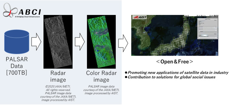
ABCI colorization of radar images
Although advances in satellite capabilities in recent years have broadened the scale, enhanced the resolution, and increased the amount of data acquired for observation, gaps in computing power have led to selective data processing.
Nevertheless, worldwide use of satellite data continues to grow, as part of social or corporate activities, and both providers and users seek timely and complete processing of acquired data.
Using ABCI, an AIST supercomputer for AI applications, the researcher performed image processing of all SAR data acquired by the PALSAR, a Japanese spaceborne microwave sensor. The full-polarimetric radar images, which are color-coded based on global ground surface conditions, were released under an open and free policy (CC BY) on the following site:
https://gsrt.airc.aist.go.jp/landbrowser/index.html
In conventional satellite data archives, image processing of satellite data has been incomplete due to insufficient computing power. This has diminished the value of satellite data, which has been underutilized and not used in timely ways. In the present research, ABCI was applied in image processing of all data (approximately 700 TB, consisting of about 2 million scenes) acquired during PALSAR's five-year period of operation between 2006 and 2011. Practicality of this approach was evaluated from standpoints such as image processing time and image quality. Data obtained in 4-component polarimetric mode for detailed analysis of ground surface conditions was processed using scattering power decomposition, a SAR data analysis method. It was demonstrated that this technique makes it easy to discern changes across broad areas over time.
Examples of image processing that makes it easy to understand sophisticated SAR images, and the release of global color radar images under an open and free policy make satellite data more readily available to potential users. These are expected to promote new applications of this data in industry and to contribute to solutions for global social issues (such as illegal deforestation and food production management) through global observation taking advantage of satellite data.