– Published the “Geologic Map of Volcanoes in Japan (1:200,000)” database with the world’s highest level of accuracy –
Researchers: KAWANABE Yoshihisa, Senior Researcher, TAKARADA Shinji, Chief Senior Researcher, and ISHIZUKA Yoshihiro, Leader, Research Institute of Earthquake and Volcano Geology, Geological Survey of Japan
- AIST has published the “Geologic Map of Volcanoes in Japan (1:200,000)” that includes information on about 440 Quaternary volcanoes in Japan on the website of AIST.
- AIST has built a volcano database system that shows the distribution of volcanic eruption products and attributes with the world’s highest level of accuracy.
- The database has an easy-to-use interface that promotes its use for a variety of industrial, government, and academic applications.
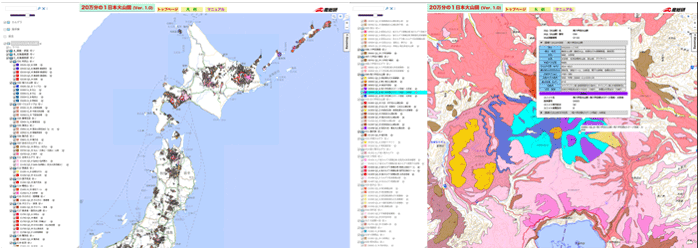
Search window on the Geologic Map of Volcanos in Japan site
Distribution of volcanic eruption products in the Northern Japan region (left) and information on eruption products (right) The background maps are GSI Maps of the Geospatial Information Authority of Japan (pale color map, standard map)
Throughout Japan there are about 440 quaternary volcanoes, some of which are active. Knowing when, where and how volcanoes have erupted in the past is important for the Japanese population to be able to receive their benefits, such as geothermal energy and land use, and to minimize future hazards. For advanced use of volcanic geological information in a manner matched to the user’s purpose of use and region, there was a need to develop an easy-to-use volcano database that classifies past volcanic activities in detail and shows the distributions of volcanic eruption products on a map with a high level of accuracy.
The researchers have published on the website of AIST (https://gbank.gsj.jp/volcano/vmap) the Geologic Map of Volcanoes in Japan (1:200,000) that lets you view and search for a distribution of volcanic eruption products and geological information of about 440 quaternary volcanoes across Japan as a new addition to the “Volcanoes of Japan” databases. (Only the Japanese version of the map is available at this moment.)
The Geologic Map of Volcanos in Japan is a database that shows, on a 1:200,000 scale, information on volcanic eruption products from quaternary volcanoes in Japan, which was developed based on a unified standard. It lets you view and search for locational information and data on eruption products with the world’s highest level of accuracy. Such information is very useful to find out about past volcanic activities, receive the benefits of volcanoes, and implement protective measures against future eruptions. Information can be searched for and displayed on the Web map, which is open to public, in an easy-to-understand manner. Geologic information on volcanos is expected to be used more widely by government, companies, and educational organizations for disaster prevention and regional development.