Researchers: Groundwater Research Group, Research Institute for Geo-Resources and Environment
Groundwater is recently regaining attention from the viewpoints of disaster response and economics, and groundwater maps (water environment maps) have been published on AIST’s website.
 |
|
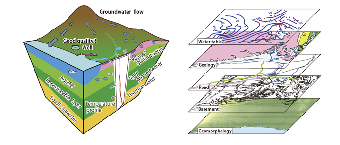
Concept of newly published “groundwater maps” (water environment maps) |
Groundwater has been used from early times in Japan as a superior water resource that maintains stable temperatures and good water quality throughout the year. However, groundwater has become distant from our daily lives for reasons such as excessive pumping. Recently, groundwater has an increasing presence due to enforcement of the Basic Law on the Water Cycle for purposes of utilizing and preserving water resources, and promotion of geo-heat utilization that makes use of the stable temperature of groundwater. However, the movement of groundwater is not visible from the ground surface, which is an obstacle for appropriate utilization.
Water environment maps of two new areas (Tsukushi Plain, Yufutsu Plain) and the previously published water environment maps of four areas (Kanto Plain, Kumamoto Region, Ishikari Plain, and Mt. Fuji) have been published on the website of AIST. In addition, the results of the wide area groundwater flow survey that has been conducted by the Groundwater Research Group since 2000 have also been published as the Groundwater Database for Japan. The information browsing lists for the web version water environment maps have been standardized, which had not been the case so far. In addition, national standardized threshold values were established for display items, and database classification and organization were carried out for the national hydrological environment database.
Water environment maps of Osaka Plain, Yamagata Basin, Niigata Plain, Shizuoka Plain, and Wakayama Plain will be prepared and published. The researchers will also provide groundwater information as needed, and work to cooperate with companies and local governments that use groundwater information.