- Lavatube2 has been developed to promote the analysis, use, and application of massive amounts of satellite data -
Kenji Iwata (Researcher), Isao Kojima (Leader), and Akihito Nakamura (Senior Researcher), Grid Service-ware Research Group, and Ryosuke Nakamura (Leader), Geoinformatics Research Group, the Information Technology Research Institute (Director: Satoshi Itoh) of the National Institute of Advanced Industrial Science and Technology (AIST; President: Tamotsu Nomakuchi), have developed image analysis workflow software, Lavatube2. It allows satellite image-analysis systems requiring the complex and high-speed processing of large amounts of data to be easily developed on the cloud (i.e. by cloud computing).
When a sophisticated computer analysis is performed, satellite images can provide high value added information useful for surveying and studying the environment, geology, and natural disasters. However, in some cases the analysis of massive amounts of image data requires high-speed processing. Because analytical processes and procedures vary depending on the type of data and the objective of the analysis, programs must be developed specifically for each type and objective. For this reason, satellite image processing has been challenging to scientists in the fields of geology and earth observation, who are not specialists in information technology and image processing.
The developed software, Lavatube2, allows an image analysis system to be developed easily and intuitively by representing, with icons, programs for performing various image analysis processes and linking the icons in the Web browser window. The image analysis system that is developed is saved on the cloud and can be reused and shared with other users. Information infrastructure that can provide new socially and scientifically useful information can be easily created with the support by Lavatube2 to research and development activities using satellite images. This will promote the use of geospatial information such as satellite images.
Details of this technology will be presented at AIST Open Lab to be held at AIST Tsukuba on October 25 and 26, 2012.
 |
|
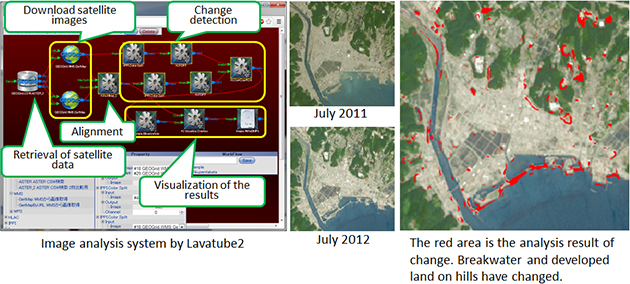
Figure 1 : Visualization by satellite image analysis of changes in the Sanriku coastal region during recovery from the Great East Japan Earthquake |
Image analysis is a technique that is required in various fields, including satellite earth observation, medical services, crime prevention, and quality inspection in factories. In recent years, it has become possible to convert image information from a number of sensors into data and to then store the data in large quantities. When a sophisticated analysis is performed, satellite images can provide high value added information useful for surveys and studies of the environment, geology, and natural disasters. Every day, large volumes of data are provided by sensors on satellites orbiting the Earth. With the availability of cloud computing technology, which allows the analysis of big data that are in large volumes and amounts, including satellite image data, new socially and scientifically useful knowledge should be obtainable. However, image data contain much more information than do structured data such as documents. Because the methods of analyzing the image data vary depending on the target and objective of the analysis, expertise is required in selecting and combining analytical methods to ensure effective use of the data.
Lavatube, which was developed in 2007 by AIST, is software that can be used to develop image analysis systems that use various algorithms and parameters. In Lavatube, an image-processing system can be easily created by representing each procedure in the program description with an icon and linking the icons. Parameters, such as the threshold for image discrimination, can be adjusted while the results of the process are being displayed on the fly, thus allowing efficient system development. Lavatube is open-source software developed for Windows. Users can freely download and install it on their PC.
AIST has created an environment that allows numerous satellite images, i.e. images from ASTER (Advanced Spaceborne Thermal Emission and Reflection Radiometer) sensors on a satellite, to be used for research within the information infrastructure GEO (Global Earth Observation) Grid for the use of earth observation data. However, a single PC has limited processing capacity and memory capacity for the analysis of such large amounts of image data. Because of this, the researchers developed the image analysis workflow software that allows an image-processing system to be readily developed by using cloud computing.
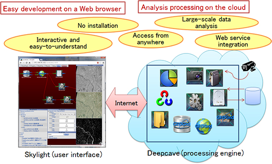
The developed software, Lavatube2, is divided into two parts: a user interface, Skylight, and an execution engine, Deepcave. The execution engine is located on the cloud and the user interface is provided from the Web browser. Figure 2 shows the configuration of Lavatube2. This configuration has the following benefits. First, installation on a PC is not required, allowing the user to use Lavatube2 independently of the equipment environment, including the performance of the PC and the operating system. Skylight is based on the latest HTML5 Web technology and allows the user to easily develop, with simple mouse operations in the Web browser window, a complex image analysis system consisting of programs to perform various processes and procedures. Data analysis by the execution engine Deepcave is performed by the cloud but not by the user's browser. This makes it possible to process massive amounts of data at high speed, making use of the computing capability of cloud computing.
 |
|
Figure 2 : Configuration and benefits of Lavatube2 |
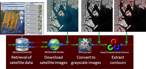
In Lavatube2, each function required for image processing is represented by an icon called a work patch (Fig. 3). Work patches for basic image-processing functions (color transformation, filtering, etc.) provided by OpenCV and other image-processing libraries are incorporated into the software. Figure 3 is an example of an image analysis system developed to detect coastlines. Shown from left to right are the satellite data search, searched image acquisition, color transformation, and outline detection processes. In Lavatube2, a system is developed by linking work patches representing processes in order of their execution. There is one-to-one correspondence between the processes actually performed and the work patches in the window, and operations can be intuitively understood and performed.
If users with expertise (e.g. image-analysis-system developers) want to incorporate their own image-processing and analysis functions into the software, they can add these as work patches.
 |
|
Figure 3 : Example of a Lavatube2 operation (detection of a coastline) |
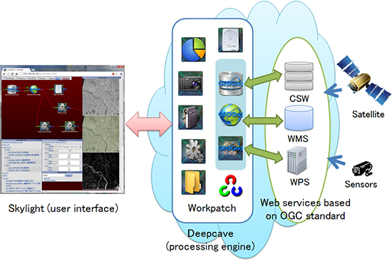
Also incorporated in Lavatube2 are work patches for geographic information applications compatible with standard specifications, namely CSW (Catalogue Service for the Web), WMS (Web Mapping Service), and WPS (Web Processing Service), formulated by the OGC (Open Geospatial Consortium), an international organization for the standardization of geospatial information. As a result, the user can easily access data archives of OGC-compatible geospatial information, including GEO Grid, and perform analyses (Fig. 4). For example, of the set of processes in Fig. 3, the processes of searching for and acquiring satellite data can be easily created. The conventional analysis process is as follows. First, the user searches for data by using a satellite data search site. After downloading the required satellite data to the PC, the user creates a program and performs the analysis. The workflow for processing and analyzing satellite images, which is complicated and time consuming, can be implemented together by using Lavatube2.
 |
|
Figure 4 : Link to geospatial information in Lavatube2 |
Figure 1 is an example of an image analysis system developed with Lavatube2 that identifies changes by comparing satellite data from different dates. The Sanriku coastal region was specified for a satellite data search, and the data for June 2011 were compared with those for June 2012 to detect and visualize changes in the region from the previous year during recovery from the Great East Japan Earthquake. Processing technology like this for detecting changes in satellite data is important for monitoring the ever-changing environment of the Earth, studying volcanic activity and disaster mitigation, and analyzing land use. However, change-detection systems are not easily developed. Analytical processes and procedures vary depending on the variations in data quality due to differences in the vegetation and weather between different times of image obtainment, objects to be detected (e.g. crustal deformations and structures), and objectives of the analysis. Therefore, the parameters need to be adjusted accordingly. Lavatube2 can be used to avoid this issue. It allows the user to develop a system through trial and error while trying different algorithms and different combinations of parameters on the fly. The image analysis system developed with Lavatube2 is saved on the cloud and can be reused and shared with other users. The user can make changes to the system to improve it. By supporting the cycle of research and development using satellite data, information infrastructure can be developed to obtain new knowledge useful to society and science. The use of geospatial information as well as satellite data analysis technology is also promoted.
Lavatube2 will be incorporated into a satellite analysis system of GEO Grid that is being developed by AIST, and it will be provided for verification as a Web-based service to researchers and technical experts in the fields of earth observation and information technology.
Because Lavatube2 can process data very easily and can detect changes in topography and land use, the researchers will make some of its functions available to non-experts to identify general needs, such as the development of municipal disaster-mitigation programs. Lavatube2 can be used to analyze image data other than satellite data. They intend to develop its application to areas where there is a demand for technology for analyzing massive amounts of image data, such as in medical image-based diagnosis and crime prevention using monitoring camera images.