Point
We completely revised the 1:200,000 Seamless Digital Geological Map of Japan that seamlessly shows geological information on all regions of Japan, and which has been available for viewing on our website. The revised map was published on May 10 (Geology Day), 2017.
(The standard map of the Geospatial Information Authority of Japan is used as the base map.)
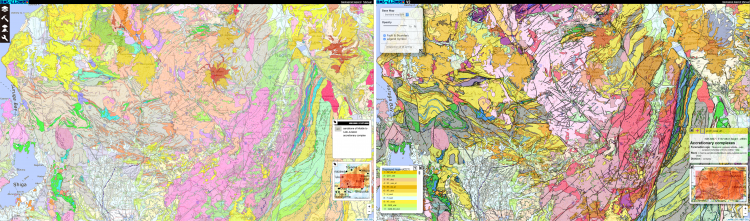
Comparison between the old (left) and new (right) 1:200,000 Seamless Digital Geological Maps of Japan (Example shows the Chubu region)
|
Background
The old 1:200,000 Seamless Digital Geological Map of Japan, which was widely used as a globally unique, web-based geological map that could be viewed quickly in detail, used a legend based on the rocks and strata classification system from the 1:1,000,000 Geological Map of Japan, Ed. 3, which was published in 1992. The legend of a geological map determines the quality and quantity of information displayed on the map. About twenty-five years have passed since the 1:1,000,000 Geological Map of Japan, Ed.3 was published, and the rocks and strata classification principle has now changed (evolved) greatly. Therefore, there was a need to newly edit the map based on a legend that includes knowledge gained over the past twenty-five years.
Outcomes and Methods
We completely revised the legend based on the latest geological knowledge. The number of legends increased markedly from the previous 386 to more than 2,400, allowing more detailed information to be shown on the geological map. The new legend has been systematized and hierarchically structured. As a result, the way in which the geological map is displayed can be changed to suit a purpose or use.
Future Plan
We are developing an option display function to display geological features by any era and type of rock. When that function is implemented, for example, disaster prevention measures can be set up by displaying specific geology to explore the risk of similar disasters and analyzing in combination with other disaster information during a disaster. The revised map is expected to contribute to the increased use of geological information in a wide variety of areas, such as civil engineering and construction, disaster prevention and mitigation, tourism, and resource exploration.
Links
Contact
 |
|
Makoto Saito
Leader
Editorial board of the Seamless Digital Geological Map of Japan (1:200,000), Geological Survey of Japan
AIST Tsukuba Central 7, 1-1-1 Higashi, Tsukuba, Ibaraki 305-8567 Japan
E-mail: soudan*gsj.jp (Please convert “*” to “@”)
|