– A next-generation geological map that can express the subsurface geological structure of central Tokyo (special wards area) in three dimensions –
Researchers) NAKAZAWA Tsutomu, Group Leader, NONOGAKI Susumu, Senior Researcher, Geoinformatics Research Group, Research Institute of Geology and Geoinformation
- Detailed 3D visualization of the subsurface geological structure of central Tokyo based on survey data from 50,000 sites
- Discovery of a soft stratum even in a location thought to be hard ground thus far from stratal distribution analysis
- Widespread use expected such as for earthquake hazard maps and urban infrastructure development in the capital city of Tokyo
3D image of the subsurface geology of central Tokyo, shown as “Urban Geological Map” on the AIST’s website
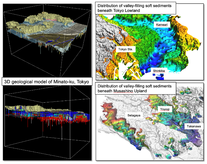
In the 2011 Tohoku-Oki Earthquake, there were numerous incidences of liquefaction damage even in the Tokyo metropolitan area centering on the bay area, and widespread building damage due to the earthquake motion was also recognized. As a result, there is a great deal of interest in the geological ground characteristics of shallow subsurface parts that have a large impact on earthquake damage. Geological information is also extremely important for efficient promotion of urban infrastructure development. However, plain areas are largely urbanized, and it is not easy to directly observe the strata, which makes it a challenge to obtain accurate information on subsurface strata. Central Tokyo is no exception, and details of the kinds and distribution of subsurface strata were unknown.
AIST has published a next-generation geological map “Urban Geological Map of Central Tokyo (Special Wards Area)”. It visualizes the subsurface geological structures beneath central Tokyo to a depth of tens of meters in three dimensions.
It was difficult to accurately express subsurface geological structures beneath urban areas with conventional planar geological maps. Analysis of large amounts of survey data from as many as 50,000 sites with originally developed 3D modeling technology enabled to visualize the detailed subsurface geological structure of central Tokyo in three dimensions. As a result, the distribution of a valley-filling soft stratum called the post-Last Glacial Maximum (LGM) deposits in the lowlands of downtown Tokyo was depicted in great detail. Furthermore, it was clarified that a weak stratum similar to the post-LGM deposits is also distributed in a part of the Musashino Upland in the Yamanote area, which had generally been considered hard ground. This 3D geological map can be easily viewed by anyone free of charge, so widespread use is expected such as for earthquake hazard maps and urban infrastructure development in central Tokyo (wards area). The map was released on the “Urban Geological Map of Central Tokyo” page of the AIST website on May 21, 2021.