Researcher) NISHIOKA Yoshiharu, Leader, Integrated Geo-information Research Group, Research Institute of Geology and Geoinformation
- Release of professional high-precision elevation data converted to PNG elevation tiles that are easy to use even on ordinary websites
- Can be easily and "freely" used by anyone
- Use expected in creation of detailed 3D map sites and for new services that address regional issues
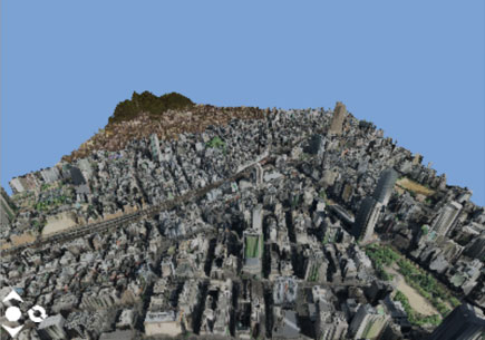
3D display of area around Sannomiya, Kobe using "Seamless Elevation Tiles"
(Geospatial Information Authority of Japan tile "photographs" are used)
A 3D model was created based on elevation tiles that include the heights of buildings, trees, and other objects in Hyogo Prefecture.
Users can freely rotate and move on a website.
Recent advances in surveying techniques such as aerial laser surveying have led to the preparation and release of high-precision elevation data. Meanwhile, the spread of the Internet environment and the increasing functionality of information terminals such as smartphones have made it easy to browse various websites, and the development and use of websites that can reflect regional characteristics using high-precision elevation data is expected as a means of addressing regional issues. However, the released high-precision elevation data are for professionals and file sizes are large, so little progress has been made in the development of 3D map sites, etc. that use these data.
"Seamless Elevation Tiles" consisting of high-precision elevation data for Hyogo Prefecture, etc. converted to PNG elevation tiles that are easy to use on the web have been released. (https://gbank.gsj.jp/seamless/elev/)
Elevation data that provide height information to planar maps are used to create 3D maps and for disaster simulations, but the source data is highly specialized information that is generally not easy to use. The released "Seamless Elevation Tiles" enable anyone to easily obtain arbitrary PNG elevation tiles, and use of those PNG elevation tiles achieves high-speed operation by 3D websites and other Internet sites. Among the released tile sets, use of elevation tiles based on high-precision elevation data for Hyogo Prefecture in particular is expected to be used for creation of detailed 3D map sites and new services that link with other map data to address regional issues such as flood damage and slope disaster prevention measures.