- An international joint research group discovered evidence of recurrent giant tsunamis -
Yuki Sawai (Research Scientist), the Subduction-zone Earthquake Recurrence Research Team (Leader: Yukinobu Okamoto), the Active Fault Research Center (Director: Yuichi Sugiyama) of the National Institute of Advanced Industrial Science and Technology (AIST) (President: Hiroyuki Yoshikawa), in collaboration with Chulalongkorn University, U.S. Geological Survey, the University of Washington and Geoscience Australia, discovered evidence of three precedents for the 2004 Indian Ocean tsunami. The evidence is tsunami deposits in a stratum accumulated over the last 2500 years at the Indian Ocean coast of southern Thailand. The youngest tsunami deposit is due to the Northern Sumatra Earthquake (2004). And older sandy deposits indicate that tsunamis with magnitudes comparable to that of the 2004 tsunami have occurred previously. Using the radiocarbon-dating method, the researchers estimated that a giant tsunami had occurred postdating 550 to 700 years ago.
The 1881 earthquake had occurred along the Sunda trench, and a tidal station in India had observed less than a meter tsunami. However, it left no significant tsunami deposit in Phra Thong Island located at 125 km north of Phuket Island of Thailand. This suggests that a tsunami with a magnitude comparable to that of the 2004 tsunami recurs once in every several hundred years.
The results will be published in the October 30, 2008 issue of Nature.
 |
|
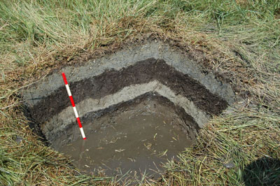
A photograph of a pit, showing tsunami deposits (light grey) interbedded with peat (dark brown). |
In the last 200 years, there were no historical documents of earthquakes with magnitudes greater than 8.0 in the Indian Ocean. The lack of experience in dealing with giant tsunamis meant that there were no opportunities to consider mitigation of tsunami disaster before the 2004 earthquake, thereby precipitating history’s worst tsunami disaster. The survey report by the United Nations presents that more than 8,000 people were dead or lost in the tsunami, of which approximately 2,000 or more were foreigners. After this disaster, a number of researchers began geological studies on the Indian Ocean coast to predict recurrence intervals of great earthquakes in Sunda Trench. A research team under the leadership of Dr. Shigeyuki Fujino of Kyoto University (currently a Post-Doctoral Research Scientist of the Active Fault Research Center, AIST) took a preliminary geological study in Phra Thong Island, southern Thailand in October 2005 and reported the existence of pre-2004 tsunami deposit (See Ref. 1). In this study, the international joint research group conducted detailed topographical and geological studies in the marsh close to the current coastline; in addition, the joint group also worked on wider areas.
Reference 1: Fujino, S., et al. (2008). Sand sheets of pre-2004 tsunamis on Phra Thong Island, Phang Nga Province, southwestern Thailand. Proceedings of International Symposium on the Restoration Program from Giant Earthquakes and Tsunamis, 115–121.
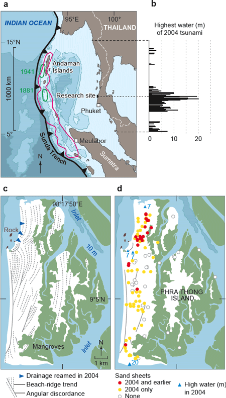
According to eyewitnesses, the 2004 tsunami, of which height was nearly 20 m, the highest in the Malay Peninsula, moved over our research site (Phra Thong Island) as much as 2 km inland (Fig. 1 a, b). Observed satellite images showed that the tsunami reamed more than 300 meters of coastal drainages at several sites in the island (Fig. 1 c). The tsunami left deposits widely across the western half of the island. In this study, we sought pre-2004 sand sheets, i.e. tsunami deposits, at the island by digging pits and augering holes into ridges and swales at more than 150 locations (Fig. 1 d).
 |
|
Figure 1 (© Nature). a: Northern Sunda Trench and vicinity. Red line shows a modeled fault slip of the 2004 Sumatra-Andaman earthquake. Green lines show historical rupture. b: Heights of the 2004 tsunami along The Malay Peninsula. c: Landforms of Phra Thong Island. Green part denotes mangroves, and white part is beach ridge plain. d: Tsunami deposits in Phra Thong Island. The 2004 tsunami heights are in meters above sea-level. |
In a couple of the coastal swales, we observed tsunami deposits and collected samples for radiocarbon dating by augering cores, excavating pits and a 35-m long trench. We confirmed the 2004 tsunami deposit on the uppermost part of the marshy sediment (Fig. 2 a, b, c, and pictures) and also two or three earlier sand sheets underlying the 2004 deposit. The radiocarbon dating indicated that the sediment accumulated over 2500 years. Because the underlying sand layers showed a similar sedimentary features to the 2004 deposit, we attributed them to tsunami deposits older than 2004. We radiocarbon-dated plant macrofossils (bark) just below the tsunami deposits and estimated that two of the tsunami deposits postdated 550-700 and 2200-2400 years ago, respectively. Assuming these ages, one of the tsunami deposits can be correlated with a tsunami deposit in Meulabor of Sumatra Island, Indonesia (Ref. 2). This suggests that the earthquake producing this tsunami was rupturing from Sumatra Island to northern part of the Sunda Trench, not from small local source.
Reference 2: Monecke at al. (2008). A 1000-year sediment record of tsunami recurrence in northern Sumatra. This article will be published in the October 30 issue of Nature, simultaneously with the results of this study.
 |
|
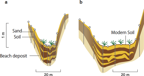
Figure 2 (© Nature). Distribution of sand sheets in coastal swales. a: Seaward swale. b: Landward swale. |
 |
 |
|
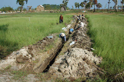
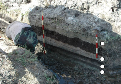
Photograph (upper): A long trench in the landward swale.
Photograph (lower) (© Nature): Tsunami deposits in the landward swale. A square shows the 2004 deposit. Three circles show tsunami deposits before the 2004 tsunami.
|
In the excavated trench, we were unable to identify significant evidence of a tsunami due to the 1881 earthquake. This is presumably because the 1881 tsunami was not large enough to leave any geological evidence in the stratigraphy. The recurrence intervals of precedent for the 2004 tsunami, calculated by the radiocarbon ages, were 1500 to 1850 years (interval between the oldest tsunami and the next-oldest tsunami) and 550 to 700 years (interval between the 2004 tsunami and the youngest tsunami that occurred before 2004). There are no historical records on tsunamis with such long recurrence intervals in the Indian Ocean. This is a reason why it was almost impossible to forecast the 2004 tsunami. However, this study also shows that the 2004 tsunami was not an unexpected tsunami from the geological viewpoint.
Tsunami geology has revealed prehistoric giant earthquakes with long recurrence intervals all over the world. Southern Kuril trench and Chile trench are among them. Further research may contribute to identify unknown giant earthquakes and tsunamis at sites where there has been no research on tsunami geology.
A number of international research teams was organized after the 2004 tsunami. The teams are conducting geological research the Indian Ocean coastal area for long-term forecasting of giant earthquakes and tsunamis. The findings of this study are a part of the results achieved by the international research. Until the end of last fiscal year, AIST was working in collaboration with the Myanmar Earthquake Commission on a geological research project that aimed to prepare Myanmar for the possibility of giant earthquakes and tsunamis. In addition to these, AIST is currently conducting similar geological research in India as a bilateral exchange project of the Japan Society for the Promotion of Science (JSPS). Moreover, a geological research project is carrying out in Indonesia in collaboration with the University of Tokyo, Hokkaido University and the Indonesian Institute of Sciences, under the auspices of the JSPS, the Japan Science and Technology Agency (JST), and the Japan International Cooperation Agency (JICA).