- Seafloor disturbance occurred at the wide region in the source area of the earthquake -
Ken Ikehara (Deputy Director), the Institute of Geology and Geoinformation (Director: Chikao Kurimoto) of the National Institute of Advanced Industrial Science and Technology (AIST; President: Tamotsu Nomakuchi), in collaboration with the Atmosphere and Ocean Research Institute (AORI; Director: Hiroshi Niino) of the University of Tokyo (President: Junichi Hamada) and Yokohama National University (YNU; President: Kunio Suzuki), conducted a seafloor survey aboard the research vessel Tansei Maru (610 tons; property of the Japan Agency for Marine-Earth Science and Technology) between July 29 and August 5, 2011. The survey confirmed the deposition of turbidite at the marine sediment surface of off the Tohoku coast from Sendai to Otsuchi that is thought to be caused by the 2011 Off the Pacific Coast of Tohoku Earthquake. The survey also revealed that, off the coast of Sendai, the seismic motion had induced morphological deformation in the marine sediment. That this deformed sediment lies just below the turbidite layer indicates that the turbidite layer was formed after the damage to the seafloor occurred. The survey results show that seafloor disturbance (destruction, deformation, and collapse) occurred at the wide region in the source area of the earthquake and that the seismic motion at the seafloor was of very great magnitude. The findings are also very significant for the study of earthquake history using marine sediments.
The results will be presented at the 5th International Symposium on Submarine Mass Movements and Their Consequences to be held at Kyoto University from October 24 to 26.
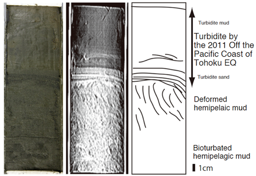 |
(Figure): A photograph of the marine sediment core collected from St. 1 off the coast of Sendai(left);
a transmission X-ray image of the core obtained through X-ray CT (center);
and a line drawing of the core (right);
Discovered just below the seafloor surface was turbidite, containing mud and differing in structure from the normal sediment.
The destructed sediment layer, which is caused by the seismic motion, was found below the turbidite. |
On March 11, 2011, the 2011 Off the Pacific Coast of Tohoku Earthquake occurred. The location of the earthquake epicenter in the seafloor off the Sanriku coast suggests that the largest topographical and geological disturbance occurred at the seafloor, yet the details remain uncertain. Clarifying the seafloor changes that were induced by the earthquake is important both for the future study of earthquakes around Japan and for mitigating the damage of future earthquakes.
In order to furnish geological information in the waters around Japan, AIST has been making marine geology maps. AIST had, therefore, already archived data on the marine sediment in the region before the occurrence of the 2011 Off the Pacific Coast of Tohoku Earthquake. Using this data, AIST, AORI, and YNU undertook the 17th cruise in fiscal year 2011 (KT-11-17 cruise: Chief Researcher: Koji Hamasaki (Associate Professor, AORI)) of the research vessel Tansei Maru (610 tons; property of the Japan Agency for Marine-Earth Science and Technology), from July 29 to August 5. The cruise mission, which was related to the earthquake emergency and was publicly sought by AORI after the earthquake, included two subjects, “Evaluating the Impact on Deep-Sea Benthos of the Great Earthquake in Eastern Japan” (Representative: Robert Jenkins (YNU)) and “Research on the Occurrence and Deposition of Seafloor Turbidity Layers due to Seismic Motion” (Representative: Juichiro Ashi (AORI)).
The above-mentioned projects are also conducted as part of the Hadal Environmental Science/Education Program. The Program, which was funded by the Nippon Foundation, was begun by AORI in 2006.
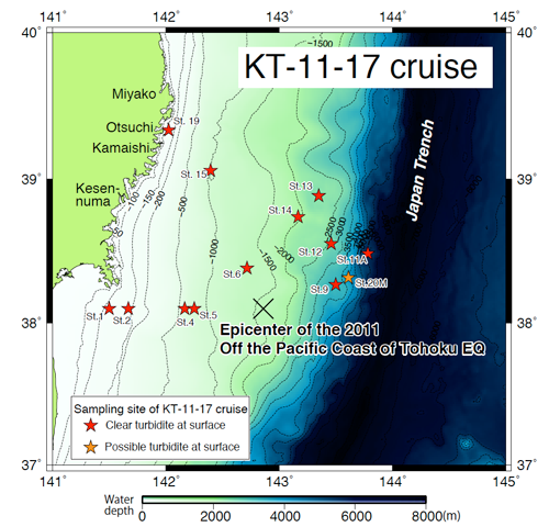
The researchers on KT-11-17 cruise collected marine sediment samples (cores) from 13 locations off the Tohoku coast from Sendai to Otsuchi at sea depths of between 122 m and 5,500 m (Fig. 1). A multiple corer was used to take undisturbed surface sediment cores. The cores underwent observation by naked eye, examination using X-ray CT equipment and transmission X-ray imaging equipment. It was confirmed that core surface sections from 12 of the 13 locations contained turbidite thought to be formed by the collapse of the seafloor and by the tsunami. The thickest turbidite was observed in the core collected from the lower region of the continental slope at a sea depth of 5,500 m. The core (about 25 cm in length) consisted entirely of turbidite.
The core taken from a sea depth of 122 m off the Sendai coast was found to contain a layer of damaged sediment some 5 cm in thickness situated below turbidite some 11 cm in thickness (Fig. 2). The damaged sediment exhibited vertical cracks and differed from the lower part disturbed by benthos. It seems that the cracked structure resulted from the collapse of the seafloor by strong seismic motion. Such large seafloor destruction caused by seismic motion was reported when the 1993 Southwest off Hokkaido Earthquake occurred. Such destruction has also been observed off the coast of Kumano, the source area of Tonankai earthquakes.
 |
|
Figure 1 : Locations where the cores were collected during KT-11-17 cruise |
The analysis used cores obtained from the 13 locations (St. 1, 2, 4, 5, 6, 9, 11A, 12, 13, 14, 15, 19, and 20M).
Turbidite was clearly present in cores from all locations except St. 20M. |
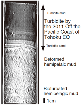 |
Figure 2 : A transmission X-ray image of the sediment core collected from St. 1 off the coast of Sendai
Vertical streaks (cracks) can be found in the sediment beneath the turbidite. |
The color and composition of the turbidite mud collected from the continental shelf and upper region of the continental slope are different from those of the turbidite mud from the mid and lower regions of the continental slope. These variations suggest that in each case the deposits forming the turbidite come from different sources. Moreover, the turbidite in the core collected at a sea depth of 893 m near the epicenter of the 2011 earthquake shows the presence of several erosion surfaces, suggesting the flowing down of several turbidity currents (Fig. 3). The evidence indicates that seafloor slope failures occurred in many locations, causing turbidity currents to flow; that the 2011 earthquake caused seafloor disturbance at the wide region in the source area of the earthquake; and that the seismic motion at the seafloor was of very great magnitude.
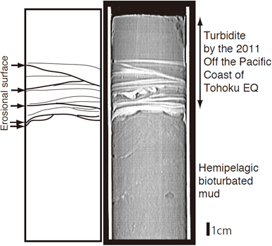 |
Figure 3 : A transmission X-ray image of the sediment core collected from St.6 near the epicenter
Several erosion surfaces are evident in the interior of the turbidite, suggesting that multiple seafloor slope failures have occurred. |
The following analyses are in progress:
1) Radioisotope analysis of the uppermost sediment layers to confirm that the sediment transport was caused by the 2011 earthquake (Hokkaido University and AIST)
2) Analysis of the composition and structure of the sediments to identify their origin (AIST)
3) Measurement of the physical properties and strength of the sediments to estimate the magnitude of seafloor seismic motion (AIST)
4) Elucidation of the impact of the earthquake on the seafloor environment by understanding the subsequent changes in marine sediment and benthos through the comparison with the data obtained by AIST in 1982 (YNU, Shizuoka University, AORI, and AIST)
5) Elucidation of the impact of the earthquake on the seawater and the seafloor environment by analyzing turbidity distribution in seawater (AORI)
The survey results confirm that a large-scale earthquake at the seafloor can cause seismic turbidite deposition in the maritime region in which the earthquake occurs. Instead of eroding, the turbidite caused by such a powerful earthquake is expected to remain as a stratum in the seafloor, where mud normally accumulates. Collecting longer core samples of the marine sediments from the region and identifying the depositional age of the seismic turbidite found within them should therefore help to shed light on the history of earthquake occurrence in the region over a long period. Future research efforts will focus on the investigation of the earthquake history using marine sediments.