– Publication of a series of “Distribution maps of large-volume ignimbrites in Japan” –
Researchers) GESHI Nobuo, Group Leader, TAKARADA Shinji. Chief Senior Researcher, Caldera Volcano Research Group, Research Institute of Earthquake and Volcano Geology
- Publication of a series of “Distribution maps of large-volume ignimbrites in Japan” as new geological information
- The first issue is the distribution map of the Ito ignimbrite that occurred in the southern part of Kyushu Island, Japan around 30,000 years ago.
- Provision of information on the impact of catastrophic eruptions that is useful for disaster prevention and social infrastructure development
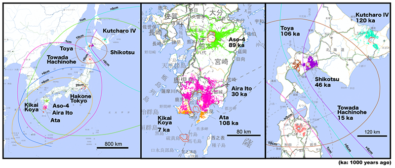
Distributions of the representative large-volume ignimbrites and associated volcanic ash fall deposits within the last 120,000 years in Japan
With the Tohoku Earthquake, society has begun to recognize the risk of infrequent but highly damaging geologic hazards. A catastrophic eruption that produces a large-scale pyroclastic flow (ignimbrite) can be expected to cause a devastating disaster not only in the vicinity of the volcano but also over a national – global area. It is essential to accurately grasp the distribution of volcanic products from past massive eruptions to predict the scope of the impact in the event of a similar eruption in the future. However, it is difficult to know the distribution of volcanic products from past giant eruptions from classic geologic maps because the deposits of giant eruptions have been covered by new eruptions or lost through erosion.
AIST started to publish a series of the distribution maps of 12 Holocene-Pleistocene large-volume ignimbrites produced by massive eruptions in Japan. The first issue is the distribution map of the Ito ignimbrite ejected by a massive eruption of the Aira caldera in the southern part of Kyushu Island, Japan around 30,000 years ago.
This “Distribution maps of large-volume ignimbrites in Japan” series provides the distribution and other geological dataset of the large-volume ignimbrite that occurred within the last 120,000 years in Japan in unified style, based on the compiling the field and borehole data. The first publication of this series is the distribution map of the Ito ignimbrite, that provides the distributions of the reconstructed distributions, surface altitude, thickness of the ignimbrite deposit, with the size and orientation of the clasts in the deposits. The total amount of the volcanic products of the eruption, including the Ito ignimbrite and associating volcanic ash, was re-estimated as 800-900 km3, which is approximately 1.5 times greater than the previous estimate. Catastrophic eruptions are infrequent but have a devastating impact in wide area when they occur. This publication series will contribute to the disaster prevention plans and national land use plans in preparation for catastrophic eruptions.