– Successful experiment identifying vehicle positions with a suspended electromagnetic sensor –
AIST has developed a system to probe from the air for vehicles buried by landslides, as an outcome of a project by the New Energy and Industrial Technology Development Organization (NEDO), in collaboration with enRoute Co., Ltd., Hitachi, Ltd., and Yachiyo Engineering Co., Ltd.
In recent years, there has been active development of drones that can be used in disaster zones. Use of drones is gaining momentum in the fields of aerial photography and survey, agricultural chemical spraying, and infrastructure inspection. It is expected that in the field of disaster response, drone technology will be applied so that we can use drones to probe for buried vehicles in disaster zones where it is difficult for humans to work.
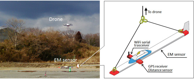
The developed system consists of a drone and an electromagnetic (EM) prospecting sensor. Using a technology that enables stable flight with the suspended EM sensor for identifying the buried vehicle position, it is capable of both comprehensive probing in automatic flight and precise probing in manual flight. Compared with helicopters, it can access narrower areas, and can probe in greater detail at a low height from the ground surface. In this research, AIST conducted verification tests on an experiment site in Shizuoka Prefecture where vehicles were actually buried, and succeeded in identifying the position of a vehicle buried at a depth of 1.5 meters.
Because the terrain is often steep in real disaster zones, flight of the drone while suspending the sensor might be destabilized. In the future, it will be necessary to conduct verification tests at experiment sites with uneven terrain, and continue to improve the system. In addition, AIST will transfer this technology to private sector companies, and promote practical application so that this technology becomes useful in disasters.
 |
|
Aerial measurements using drone-suspended electromagnetic prospecting system (left) and sensors (right) |