Update(MM/DD/YYYY):04/24/2018
Complete Revision of the Web-Based Geological Map of Japan
– Completion of a new 1:200,000 high-resolution seamless geological map of Japan based on new classification –
Points
-
The old 1:200,000 Seamless Geological Map of Japan has been reviewed for all regions of Japan and recompiled based on the latest knowledge.
-
The number of new legends which reflect research developments over the past quarter-century has been increased from the previous number of 386 to more than 2400.
-
Because the legend has been structured hierarchically, it is possible to display the map flexibly depending on purposes or uses.
Summary
The Committee on the Compilation of the 1:200,000 Seamless Geological Map of Japan (Chairman: Makoto Saito), the Geological Survey of Japan (GSJ; Director General, Yusaku Yano), the National Institute of Advanced Industrial Science and Technology (AIST; President: Ryoji Chubachi), has completely revised the 1:200,000 Seamless Geological Map of Japan that seamlessly shows geological information on all regions of Japan and has been available for viewing on our website since 2005. The revised map has been published on May 10 (Geology Day), 2017 (https://gbank.gsj.jp/seamless/v2full/?lang=en).
The old 1:200,000 Seamless Geological Map of Japan, which was widely used as a globally unique, web-based geological map that could be viewed quickly in detail, used a legend based on the rocks and strata classification system from the 1:1,000,000 Geological Map of Japan, which was published in 1992. The legend of a geological map determines the quality and quantity of information displayed on the map. About 25 years have passed since the 1:1,000,000 Geological Map of Japan was published, and the rocks and strata classification principle has now changed. Therefore, the committee has completely revised the legend based on the latest geological knowledge. The number of legends has increased markedly from the previous number of 386 to more than 2400, and more detailed information can now be shown on the geological map. The new legend has been systematized and structured hierarchically. As a result, the way in which the geological map is displayed can be changed to suit a purpose or use.
The revised map is expected to contribute to the increased use of geological information in a wide variety of areas, such as civil engineering and construction, disaster prevention and mitigation, tourism, and resource exploration.
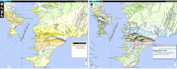 |
|
(The standard map of the Geospatial Information Authority of Japan is used as the base map.) |
Comparison between the old (left) and new (right) 1:200,000 Seamless Geological Maps of Japan
(Example shows the area between the Miura Peninsula and the Boso Peninsula.) |
Social Background of Research
A geological map is a map that shows the type, geological age, and distribution of strata and rocks under vegetation and soil, and their relationship. Information of a geological map shows ground conditions; the locations of active faults; the presence of underground resources such as coal, natural gas, hot springs, and geothermal energy; and the history of volcanic activities. For this reason, geological maps are used in a wide variety of areas, including resource exploration, civil engineering and construction, disaster prevention and mitigation, and (in recent years) tourism, thus supporting our lives. Japan, where four tectonic plates move against each other, has a very complex geological structure. Geological maps that show how structures were formed, and their status, play an important role in achieving a safe and secure society.
GSJ at AIST created a 1:200,000 digital seamless geological map of Japan, covering the Japanese Islands, from 1:200,000 quadrangle geological maps and published it on our website in 2005. Anyone can easily view the seamless geological map of Japan on a PC, tablet, or smartphone. This is the only geological map that allows all the regions of Japan to be viewed with a single legend. There are no other systems in the world that allow quick viewing of a geological map containing as much information as this one. Since publication of the map, the number of views it has received has continued to increase. The front page has been viewed more than 1 million times.
However, this 1:200,000 Seamless Geological Map of Japan was created by using the legend from the 1:1,000,000 Geological Map of Japan, which was published in 1992. The basic concept of the legend used is about 25 years old. Legends are words that express the information of geological maps. Unless a legend is renewed, it is difficult to create a geological map that contains new ideas. It was therefore necessary to create a new legend based on advances in geology over the past 25 years and to compile a new geological map by using the new legend.
In 2010, the Committee on the Compilation of the 1:200,000 Seamless Map of Japan, which consists of specialists from various fields, was organized. The committee created a legend based on the latest knowledge and recompiled the 1:200,000 Seamless Geological Map of Japan by using the new legend.
Details of Research
The fully renewed legend consists of more than 2400 legends combining three categories: the geological age of rocks and strata, the kinds of rock types, and the sedimentary environment of strata or tectonic settings of rocks. The number of legends has increased markedly from the previous number of 386. The classification of all rock types has been revised to provide a geological map using a more detailed legend.
The major change is that the classification of rock types and geologic time which were inconsistent, has been unified. Sedimentary rock has been classified so that it can be determined where the rock was deposited: for example, whether it was deposited in the sea or on land. The constituent-based classification of volcanic rock has been made more detailed so that it is in exact agreement with the ordinary classification of lava from volcanoes in Japan (Fig. 1). Metamorphic rock has been classified so that the rock before being metamorphosed, and the pressure and temperature to which the rock was exposed, can be shown. Many rocks and strata have newly been classified as accretionary complexes that form the backbone of the Japanese Islands. Strata determined not to be accretionary complexes have been separated from those collectively classified as accretionary complexes, and the kinds of rock types have been increased so that each rock or stratum can be classified accurately.
Consequently, it will be possible to accurately determine the correlation between kinds of strata or rock types and the occurrence of disasters. An accurate distribution of strata and rocks can be used to determine the distribution of resources such as geothermal energy and ground heat sources, and to explore nonmetal resources. In addition, knowing accurately how the land where people live was formed will help us to better understand the history of geological hazards in the region, as well as to deeply understand our local history and develop new tourism resources.
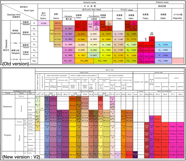 |
Figure 1 Comparison between the old legend (top) and the legend of newly published map (bottom)
An example of igneous rocks of the same geological age
The classification of rocks in the new legend is hierarchically structured and detailed. |
Hierarchical structuring was a particular concern in revising the legend. Three categories—the geological age of rocks and strata, the kinds of rock types, and the sedimentary environment of strata or tectonic settings of rocks—have been hierarchically structured (Fig. 2). This makes it possible to view a map, which will be used for a particular purpose or use, with selected geological information from the newly published map. For example, in the civil engineering and construction field, the strata type associated with soft ground can be shown in detail, whereas old and hard rocks can be shown by a broader classification. In developing measures to mitigate mudflow and landslide hazards caused by earthquakes or heavy rainfall, local governments can display in detail the distributions of the rocks involved and can surmise the relationships between the rocks and mudflow or landslide hazards to develop the most appropriate measures to ensure safety. In addition, to prevent volcanic hazards, only the legends for volcanic rocks can be shown in detail; other legends can be shown by a broader classification. Data in the commonly used geographic information system (GIS) format will be made available publicly, making it easy to use existing application software.
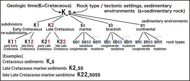 |
Figure 2 Example of hierarchically structured legends
An example of sedimentary rocks in the Cretaceous Period
Rocks can be shown by a broad classification as well as by a detailed classification. |
The old 1:200,000 Seamless Geological Map of Japan allows various types of information, such as the locations of active faults, to be shown overlaid on the map, which is very convenient. The new geological map is more detailed and is expected to make it easier to understand the relationships with overlaid information. The new map allows more effective and sensible disaster prevention and mitigation measures to be taken, such as determining appropriate evacuation routes by overlaying regional administrative information on the map. In the field of tourism, how the landscape in a region was formed can be explained by using the latest geological information.
Future Schedule
GSJ plans to improve the usability of the map, for example, by enabling it to be overlaid with other information such as active fault information, as with the old seamless geological map, and to prepare whole data download. GSJ will notify the new map’s completion to outside websites where various types of information are overlaid on the old seamless geological map, and it will develop and provide various application software programs that utilize the hierarchically structured legend.