- Promoting use of optical sensor data from the Earth observation satellite TERRA -
On April 1, 2016, the Research Institute of Geology and Geoinformation (Director: Masahiko Makino) of the National Institute of Advanced Industrial Science and Technology (AIST; President: Ryoji Chubachi) begins to provide processed data from an earth observation satellite, the value-added product “ASTER-VA”, at no cost (https://gbank.gsj.jp/madas/).
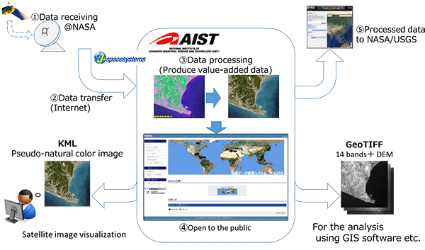
AIST observes, through the Internet from the United States National Aeronautics and Space Administration (NASA), satellite data obtained by the optical sensor ASTER, which was developed by the Japanese Ministry of Economy, Trade and Industry (METI) and is installed on the earth observation satellite TERRA operated by NASA, process this information and provide it using an easily understood interface. ASTER-VA consists of image data that applies AIST’s original pseudo-natural color image synthesis technology, in addition to elevation data and data with pre-corrections of irregularities of terrain and deviations for superposition with maps including geological information (ortho-rectified). Users can select from two types of file format, so that it can be used with various geospatial information software.
ASTER-VA is equipped with data of the entire world, and can be used in a wide range of fields including disaster prevention, the environment, and agriculture, forestry, and fisheries. As public data with no limitations on its use (intellectual infrastructure data), it is also expected to be used in businesses utilizing geospatial information.
 |
|
Value-added product ASTER-VA data generation and distribution mechanism and envisioned uses |
Satellite remote sensing technology, which observes the area around the Earth’s surface from sensors mounted on satellites, can continuously measure the Earth in a wide range with the same sensors, so this technology is used broadly for environmental impact assessment on a global scale, as well as damage estimation during large-scale disasters such as typhoons and earthquakes.
Yet satellite data recorded in the past are limited. And there are few long-term observation sensors being operated for 10 years or more since the beginning of the 2000s. Even Landsat, the longest operating Earth observation satellite which has offered public domain data since 2008, has suffered a failure in part of its observation data due to malfunction in its sensors in 2003. Against this background, there has been high potential demand for satellite data with similar performance to Landsat available at no cost.
AIST has been involved since the development stage of the ASTER sensor, and has archived data collected from ASTER for over 15 years since the start of operations in 2000. The Research Institute of Geology and Geoinformation and the Information Technology Research Institute of AIST have developed a data processing, distribution, and access technology prototype system as part of the GEO Grid (Global Earth Observation Grid) project, and have conducted petroleum resource exploration technology development and geological disaster monitoring research of earthquakes and volcanic activities using ASTER. (AIST press release on October 21, 2005 and AIST research result announced on May 17, 2007).
In order to promote the use of such geospatial information not only in disaster prevention measures and resource exploration, but in a variety of businesses, it would be necessary to widely publish high quality data that adds value meeting needs of industry to conventional data obtained from ASTER, as an intellectual infrastructure. For this reason, AIST decided to conduct research and develop a system to provide the value-added product ASTER-VA which can be used in a wide range of business scenarios, in international cooperation with NASA.
The developed system consists of a system to produce the value-added product ASTER-VA and a system to conduct operation, data processing, and data distribution of ASTER.
1. The ASTER-VA production system and types of data provided
By design, ASTER does not have blue band information. Therefore, AIST developed its original technology to estimate blue and synthesize pseudo-natural color images, and mounted features in the system to convert ASTER data into natural color data that is easily observed and understood by the human eye. This makes, for example, forested areas appear as a more natural green (Fig. 1). Because topographic correction is necessary to superimpose satellite data with other geospatial data, such correction (ortho-rectified) is conducted on all ASTER data, making it easy to superimpose on geospatial information.
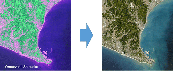 |
Figure 1: ASTER-VA data of the area around Omaezaki, Shizuoka Prefecture
(left: before natural color correction, right: after natural color correction) |
The spatial resolution of the Earth observation data to be provided is even higher than the spatial resolution of the Landsat data, and has a larger number of bands. It is 15 m (3 bands) in the visible light region and the near infrared region, 30 m (6 bands) in the short wavelength infrared region, and 90 m (5 bands) in the thermal infrared region (In the case of the freely published Landsat 8 data, it is 30 m, 9 bands in the visible light region to the mid-infrared region (Band 8 only being 15 m), and 100 m, 2 bands in the thermal infrared region).
In addition to these types of satellite observation data, the system also provides elevation data produced from ASTER data.
2. System for operation, data processing, and data distribution of ASTER
Based on the comprehensive cooperation agreement concluded between METI and NASA, AIST has been cooperating with Japan Space Systems (JSS) since December 2014 to build a system to provide data to NASA and the US Geological Survey (USGS) as an official data processing institution, and is engaged in the processing of ASTER data. AIST has also conducted operation of monitoring of sensor equipment under steady-state operation and a long-term observation plan including emergency observation plans, in cooperation with NASA and JSS.
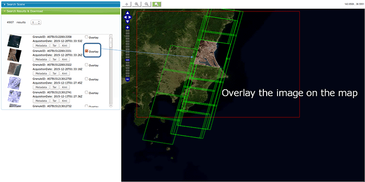
The ASTER-VA data was produced by further value-added processing of ASTER data accumulated in this system, and users can search data by specifying the observation time and date or the amount of clouds covering the image (Fig. 2). Images of search results are displayed on the left side of the screen as thumbnails, and required data can be downloaded. Clicking “Overlay” displays the selected ASTER-VA (pseudo-natural color image) on the map (Fig. 3).
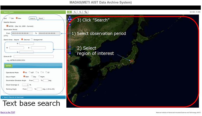 |
Figure 2: Layout of the image search screen
1) Select observation period when the image was acquired (start date and end date),
2) decide the region of interest you wish to search for, and 3) click “Search” |
 |
|
Figure 3: Search results screen |
Either KML format or GeoTIFF format can be selected for ASTER-VA data, and the data can be easily downloaded regardless of the format.
KML format ASTER-VA data can be displayed on Google Earth™ etc., and are already ortho-rectified, and pseudo-natural color image synthesis technology is applied to make the state of the Earth’s surface easily recognizable. The data can also be viewed on tablet devices and smartphones using satellite image visualization software. Elevation data is not included in KML format ASTER-VA data.
GeoTIFF format ASTER-VA data includes all ortho-rectified data and elevation (geospatial resolution of 30 m) excluding backward viewing data (Band 3B). Images to which the pseudo-natural color image technology is applied are not included in GeoTIFF format ASTER-VA.
ASTER has an observation record of over 15 years, greatly exceeding the initial design life of 5 years, and is in a condition still capable of long-term observation. In order to effectively use this valuable data, AIST will conduct research and development focusing on hardware (ASTER sensors), streamlining of operations including those related to archives, and on data distribution, based on the joint research plan with JSS. AIST will also promote joint research with companies wishing to create new business using ASTER.