Update(MM/DD/YYYY):11/20/2013
Discovery of Volcanic Activity Area West of Tokuno-shima Island, Kagoshima Prefecture
- Hydrothermal activity accompanied by gas bubbles was confirmed -
Points
-
Discovery of a crater-like morphology with multiple plumes at a submarine volcano to the west of Tokuno-shima Island
-
Submersible observation and sampling using a remotely operated vehicle (ROV)
-
Confirmation of turbidity in the waters as well as gas bubble release and hydrothermal venting from the seafloor
Summary
Kohsaku Arai (Leader) and others of Marine Geological Research Group, the Institute of Geology and Geoinformation of the National Institute of Advanced Industrial Science and Technology (AIST; President: Ryoji Chubachi), have discovered a new, previously unknown submarine volcanic activity area west of Tokuno-shima Island, Kagoshima Prefecture. The discovery was made by marine geological surveys conducted around Tokuno-shima Island between July 20 and July 30, 2013, using the marine resource research vessel Hakurei (6,283 tons, owned by Japan Oil, Gas and Metals National Corporation (JOGMEC)).
Using multi narrow-beam echo sounder at the area to the west of Tokuno-shima Island led to the discovery of the crater-like morphology with a width of approximately 500 m with plumes of acoustic anomalies. Submersible observation using the ROV was conducted and turbidity in the waters, and gas bubble release and active hydrothermal venting from the seafloor were confirmed. The region is located to the south west of Tokara Islands that has currently active volcanic islands, confirming the extension of active volcanic activity from the islands into the waters. This discovery is expected to contribute to bringing about new scientific knowledge such as the origin of volcanic activity in the Tokara Islands.
There is a possibility that the hydrothermal activity accompanying submarine volcanoes may form submarine hydrothermal deposits. The new discovery of the area, where their existence is suggested, is important for the marine resource development plans of the country. Further surveys will be undertaken, in collaboration with the Ministry of Economy, Trade and Industry (METI) and other organizations involved, toward the development of marine resources.
 |
|
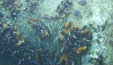
An image of the seafloor near a hydrothermal vent
The image near the vent was taken by a camera mounted on the ROV. Sulfide loving creatures, such as tubeworms and bathymodiolus, as well as white precipitates considered to be sulfides can be seen. |
Social Background of Research
Geological information based on scientific knowledge such as the research into the formation and eruption mechanisms of the volcanoes and the mechanism of subduction-zone earthquakes on both areas not only onshore but also offshore is one of important intellectual infrastructures, because Japan lies along the subduction-zone of oceanic plates. In addition, provision of geological information that contributes to the management, preservation and development of Japan’s territorial waters and its exclusive economic zone (EEZ) is an important issue from the viewpoint of development and the use of the marine resources of oceans around Japan. Especially, the government is conducting surveys and research into submarine hydrothermal deposits aiming at the commercialization of them, as they are expected as a future source of mineral resources. The discovery of new areas with possible hydrothermal activity in the vast territorial waters and EEZ of Japan will be of great importance in grasping the resource potential for the sustained and stable supply of mineral resources.
History of Research
AIST has been continuously preparing and publishing marine geology maps for the improvement of geological information on the offshore area around Japan in accordance with the intellectual infrastructure improvement plan of METI. Surveys of the sea around four main islands of Japan (Hokkaido, Honshu, Shikoku, and Kyushu) were completed in FY2006 and from FY2008, marine geological surveys commenced in the offshore area around the Ryukyu Island Arc where infrastructural information has yet to be organized. The data obtained is also used as scientific basic data for the evaluation of active faults, analysis of tectonics, marine resource development, and seafloor usage as well as for the oceanography and environmental studies. In the marine geological surveys of the offshore around Okinawa, many submarine volcanoes accompanied by calderas west of Kume-jima Island were confirmed in FY2010 and 2011, and new submarine hydrothermal activity was discovered in the cruise of FY2012. (AIST press release on December 12, 2012). However, on that cruise, actual observation of hydrothermal venting could not be done due to the limitations of the research vessel and on-board equipment. In FY2013 cruise, the marine geological surveys were conducted using the newest marine resource research vessel, the Hakurei, with on-board observation equipment to improve the marine geological information of the offshore area around Tokuno-shima Island.
 |
|
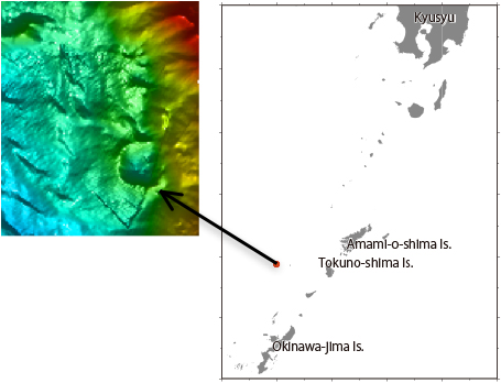
Area where submarine volcanic activity was discovered
(Left) Crater-like morphology was collected by the multi narrow-beam echo sounder
(Right) Map of the area around the location of the submarine volcanic activity (Red circle denotes the area of volcanic activity) |
Details of Research
In the marine geological surveys conducted in the offshore area around Tokuno-shima Island, detailed bathymetric surveys using the multi narrow-beam echo sounder, seismic reflection surveys to investigate geological structures and stratigraphy, and geophysical exploration to survey differences in the materials such as rocks reflecting the geological structure using gravity and magnetic anomalies were undertaken. In addition, samples of rocks and sediments were collected. In the bathymetric surveys using the multi narrow-beam echo sounder, at a submarine volcano west of Tokuno-shima Island, a crater-like morphology with a width of approximately 500 m was discovered. In addition, plume-shaped acoustic anomalies were confirmed by the multi narrow-beam echo sounder and sub-bottom profiler (Fig. 1).
 |
|
Figure 1 : Rising plumes captured as acoustic anomalies by the echo sounder
The picture shows, from left to right, data collected at intervals of several seconds. The yellow green bands that rise towards the surface from the seafloor indicate each plume-shaped acoustic anomaly. The colors indicate the intensity of acoustic reflection, redder being stronger and bluer being weaker. |
Real time submersible observation using the high definition TV camera mounted on the ROV was carried out in the waters where the acoustic anomalies were found, and turbidity of the waters and gas bubbling from the seafloor were confirmed. In addition, hydrothermal vents were discovered. Tubeworms and bathymodiolus which prefer sulfates, which are characteristics of the biocenosis of hydrothermal vents, and white precipitates considered to be sulfates from the vents were clearly identified around the vents. Running concurrently, along with the real time submersible observation, pinpoint collecting of rock samples was carried out using the manipulator arm installed on the ROV (Fig. 2). In addition, rises in the water temperature near the seafloor were also observed using the thermometer attached to the ROV (Fig. 3).
 |
|
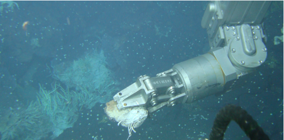
Figure 2 : A rock sample being collected by the manipulator
Submersible observation of seafloor was undertaken using the high-definition camera and pinpoint collecting of rock samples for analysis was carried out. |
 |
|
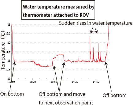
Figure 3 : Temperature anomalies at the seafloor recorded by the thermometer attached to the ROV
The ROV first landed on the seafloor and undertook observation of and took samples from the seafloor, and left after approximately 2 hours of observation.
Periods with sudden rises in water temperature occurred at observation points close to the hydrothermal vents. |
As a result of the bathymetric survey, there is a high possibility that further hydrothermal activity areas exists, because multiple craters and caldera morphology have been confirmed in the vicinity. The following analyses are currently being conducted on the collected data and samples.
-
1) Bathymetric analysis to understand the volcanic zone formation process
-
2) Analysis of geophysical survey data to understand the sub-bottom geological structure
-
3) Mineral and chemical analysis of collected rock samples for resource potential assessment
-
4) Dating of rock samples to clarify geological structure development history
Future Plans
In addition to the analysis of collected samples and data, a detailed bathymetric survey around the submarine volcanoes and collecting of further rock samples will be carried out in order to clarify the geological development mechanism of the submarine volcanoes. In addition, since there are expectations of mineral deposit formations accompanying the hydrothermal activities, studies on the extent of the distribution of hydrothermal activities, the forms of activity, and the possibility of existence of mineral deposits will be conducted by the Resource Exploration Task Force, established jointly with JOGMEC on August 2, 2013.