Japan's First Detailed National Geological Map with a Scale of 1/1,000,000
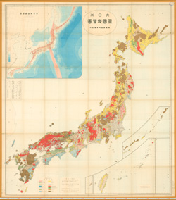
Geological maps indicate the distribution of strata and rocks under the ground, and have been created as basic maps for resource development and national land use. In recent years, such maps have also been used as important sources of information for alleviating natural disasters. The Geological Map of the Japanese Empire, which was published in 1899 by the Geological Survey of Japan, is the first geological map to include the entire geological distribution of the nation on a single sheet. The following year, an explanatory text and English version of the geological map were published. This geological map garnered attention from geologists around the world, along with the superior printing technology of Japan at the time.