– Enabling assessment of short term pollution situations and estimation of concentration in worst case scenarios –
Haruyuki Higashino (Leader) and Yuriko Ishikawa (Senior Researcher) of Environmental Exposure Modeling Group, the Research Institute of Science for Safety and Sustainability (Director: Kazumasa Honda) of the National Institute of Advanced Industrial Science and Technology (AIST; President: Ryoji Chubachi), have added new features assuming chemical leakage accidents to the previously released “Atmospheric Dispersion Model for Exposure and Risk Assessment” (atmospheric model), ADMER, and the “Standardized Hydrology-based Assessment Tool for Chemical Exposure Load” (river model), SHANEL, which are used for chemical risk assessment, and will release these as ADMER Ver. 3.0 and SHANEL Ver. 3.0.
In the atmospheric model ADMER Ver. 3.0, the researchers improved functionality to estimate concentrations of chemicals at higher time resolution of 4 hours intervals than the previous 1 month, and in the river model SHANEL Ver. 3.0, they improved the temporal resolution from monthly to daily, and improved spatial resolution 16 times over the previous model. The addition of these functions enabled estimation of short term pollution situations by chemicals, and impact assessment assuming chemical leak accidents. These models are expected to be used by the national government, local governments, and corporations.
(Background Map Data: NASA, TerraMetrics, DigialGlobe, Digital Earth Technology)
Atmospheric model ADMER Ver. 3.0
|
|

(Background Map Data: Zenrin)
River model SHANEL Ver. 3.0
|
|
Atmospheric and river models which can estimate short term pollution situations and see those results on Google EarthTM |
The impact on the environment of chemical leak accidents has gained societal attention, and initiatives are demanded of corporations and local governments to reduce the risk to humans and the ecosystem when an accident occurs. In planning risk reduction measures, it is necessary to estimate what degree of impact there would be at the maximum and pre-determine the risk before an accident occurs.
In recent years, there is rising need for technology to assess the impact on the environment affected by chemicals emitted in a short period of time, in cases where chemicals are leaked due to industrial accidents, or natural disasters including earthquakes like the Great East Japan Earthquake.
AIST has developed models for environmental risk assessment of chemicals emitted on a daily basis. It has released ADMER, which can calculate the concentration of chemicals in the atmosphere with the emission amount and meteorological data, and SHANEL for risk assessment of chemicals in water systems such as river basins.
By using ADMER and SHANEL, the number of assessable regions and chemicals across the country increased dramatically. They enabled quantitative assessment of what sources cause high concentration, and have become risk factors for polluting the environment, even if actual observation data on concentration is insufficient. Additionally, because they can also perform quantitative assessment of risk reduction measures, they have been used in risk assessment and countermeasure assessment by local governments and industry associations.
However, all of the models released so far cover chemicals emitted on a daily basis, and do not handle scenarios in which chemicals are emitted in a short period because of accidents or the like. Therefore, AIST decided to improve the functionality of ADMER and SHANEL for prediction of pollution assuming sudden emission of contaminants caused by natural disasters such as earthquakes and industrial accidents.
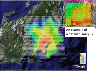
The atmospheric model ADMER is an atmospheric diffusion model developed for risk assessment of chemicals, which runs on personal computers. By built-in basic data such as weather and population, and preparing the amount of emissions and simple physical properties as input data, it can estimate the atmospheric concentration, amount of deposition, and the distribution of the exposure population of chemicals at a detailed spatial resolution (5 km to 100 m grid). Since the β edition (Ver. 0.8β) was first released in 2002, it has been used by a variety of institutions including the national government, local governments, educational institutions, and corporations for risk assessment of atmospheric chemicals. Over 6,000 people have downloaded ADMER, making it the most prevalent atmospheric model in Japan.
The atmospheric model ADMER was designed to be convenient for estimating and assessing average concentration over a relatively long period of time (monthly average). To make ADMER usable in situations where pollutants are suddenly emitted, including industrial accidents and natural disasters such as earthquakes, the new functional improvements support short term assessment by improving temporal resolution, and added new features such as extraction of worst-case conditions and source-receptor matrix analysis to support estimation of short term pollution situations assuming sudden emission due to accidents.
1. Functional improvements implemented in ADMER Ver. 3.0
(1) Support for short-term assessment In the previous version of ADMER, 4-hour average weather data was used for tabulation to estimate monthly average concentration. The improved version computes diffusion by using meteorological data every 4 hours without any tabulation. This makes it possible to calculate diffusion reflecting the weather conditions every 4 hours on specified dates.
(2) Worst case estimation
This added function can identify the date and time of peak concentration in the simulated time period for a specified location. In addition to arbitrarily specified points such as the source or observation point, it is also possible to specify another point that is a certain distance from the source. Using these functions, it is for example possible to find such information as the date and time and concentration distribution of peak concentration at points 5 km away from the source in the past 10 years, with very simple operations.
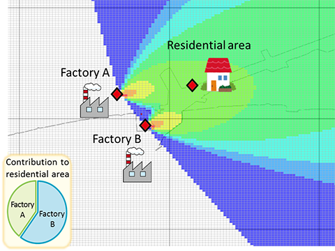
(3) Enhanced source analysis function
A new function was added to estimate the source contribution rate for a pre-set point by creating a source-receptor matrix. This makes it possible for example to know by using simple operations what source caused points of elevated concentration (Fig. 1).
 |
|
Figure 1: Example of chemical source contribution ratios estimated with ADMER Ver. 3.0 |
(4) Improvements to the system
Many improvements were made, such as improving usability by standardizing emission amounts and computation results data found with mixed resolution levels, eliminating memory shortage problems by rebuilding systems assuming for 64 bit operating systems, and raising computation speed by revising processing systems.
The river model SHANEL is a model necessary for risk assessment of chemicals in river basins, which estimates concentrations of chemicals in river water. It has built-in river basin data in tertiary mesh resolution (approx. 1 km squares), including population, land use, and sewers, and is capable of calculating concentrations of chemicals in river water on a computer simply by inputting meteorological data and the discharge volume and basic physical properties of the chemical substance . After the release of Ver. 0.8 in 2004, the model was variously improved, including the expansion of target river basin areas. The currently released Ver. 2.5 can compute concentrations of chemicals in river water in tertiary mesh resolution (approx. 1 km squares) and on a monthly basis for 109 class A river systems across Japan.
SHANEL has been used by major detergent corporations and so on for ecological risk assessments of various surfactants used nationwide. Additionally, because of rising needs for short term exposure analysis when an accident causes sudden emission of chemicals into a river, it improved on the previous temporal resolution to enable shorter term assessment, and also allows analysis of a smaller area than before by improving spatial resolution. Also, it added a function that can estimate concentration for small flow rate worst cases in a short period of time.
2. Functional improvements made in SHANEL Ver. 3.0
(1) Improved temporal and spatial resolution
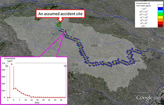
The previous SHANEL was a model for estimating concentrations of chemicals in river water in a tertiary mesh unit (approx. 1 km squares) by the month for 109 class A river systems in Japan. The version upgrade to SHANEL Ver. 3.0 enables estimation at a temporal resolution of one day. It also improves spatial resolution for all of Japan from the previous mesh size of approx. 1 km squares to that of 250 m squares. These additional features make it possible to not only assess the risk of chemicals used in everyday life and industry, but also estimate the change in concentration when chemicals are suddenly emitted in an accident, enabling predictions of area and duration of impact from an assumed point of a leakage accident (Fig. 2).
 (Background Map Data: Zenrin) (Background Map Data: Zenrin) |
|
Figure 2: Example of concentration distribution map in a simulated accident with SHANEL Ver. 3.0 |
(2) Worst case concentration estimates
With SHANEL Ver. 3.0, it is possible to temporally and spatially estimate in detail the concentration of chemicals discharged into a river, but the larger the river basin, the more time it will take to compute. By adding a feature to estimate concentration with the flow rate in fine weather, it is now possible to estimate the concentration distribution in a worst case scenario in a short period of time.
(3) Display river water concentration maps using map software
Using free map software such as Google Earth™ and a GIS viewer, ArcGIS Explorer Desktop, it is now possible to display distribution maps of concentrations of chemicals in river water and river flow rates with more convenient and detailed background map data. These make it easier to visually comprehend the area of impact from the source.
(4) Updated river basin mesh data for all of Japan
SHANEL comes equipped with mesh data necessary for computation, including population, land use, sewers, and sewage treatment plants for the entire nation. This version upgrade responds to the need for updated sewage coverage and sewage treatment plants with data from the latest year available (2011) at present.
The researchers have a plan to proceed with development of an international edition of these models so that Japanese corporations can use them not only domestically, but also abroad.