A joint survey team consisting of National Institute of Advanced Industrial Science and Technology, or AIST (Hiroyuki Yoshikawa, President), Universidad Catolica de Valparaiso (UCV), and United States Geological Survey (USGS) has discovered 8 sand sheets representing repeated seismic events in the coastal marsh located in the midway along the source region of the 1960 Great Chile earthquake. Geological evidence indicates that sand has been deposited by environmental changes resulting from tsunamis and coseismic subsidence that have occurred during the past 2000 years. The uppermost sand sheet was deposited as a result of tsunami associated with the 1960 earthquake. These findings indicate that large earthquakes of the same scale as the 1960 earthquake have long been occurring on a regular basis along the Chile Trench. Radiocarbon dating results of the deposits reveal that these large earthquakes occur about every 300 years.
Historical records since the 16th century indicate that major earthquakes have occurred about every 100-150 years (1575, 1737, 1837, 1960). However, according to sedimentary records found in this study, the predecessor to the 1960 earthquake of the similar magnitude was the 1575 earthquake, with the 1737 and 1837 earthquakes being of somewhat smaller in scale. This may be why there is no trace of the latter two events in the sediments. The same kind of phenomena has been discovered by AIST surveys along the Kurile Trench. The earthquakes that occur regularly along convergent plate boundary are believed to unusually large in scale. One such large earthquake may well have been the December 26, 2004 earthquake that occurred off the coast of the Sumatra Island.
* The results of this research appear in the September 15, 2005 issue of Nature.
 |
|
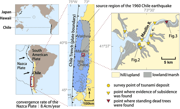
Figure 1 Off the south-central Chile, the Nazca Plate subducts beneath the South American Plate. The interface between these plates was the source resion of the Magnitude 9.5 earthquake of 1960. The resulting tsunami and vertical crustal movement left their marks on the coastal geomorphology and geology.
|
In order to predict the long-term occurrence of earthquakes, it is important to understand the history of paleo-earthquakes and estimate the recurrence interval. The AIST has been working with the USGS to survey the Kurile Trench, the Cascade in North America, and other seismically active areas. The results of this research are contributing to the recurrence of subduction zone earthquakes, tsunamis, and other seismic phenomena.
However, the seismic history along the Chile Trench, which was the source region of the largest earthquake ever recorded, the 1960 great Chile earthquake, is still not well understood. The destructive force of the tsunamis that are generated along this trench can reach all the way to Japan. Therefore, an historical understanding of the earthquakes in this faraway region can be extremely important for preventing disasters in Japan.
In this region where historical records are lacking, geological and geomorphological approach is the most effective ways to understand the paleo-seismicity. Therefore, a 3-nation team composed of researchers from the AIST, UCV, and USGS jointly undertook a study of an area where there is an actual record of the tsunami and crustal movements that occurred during the 1960 great Chile earthquake.
Along the ocean trench off south-central coast of Chile, the Nazca Plate is subducting at a rate of 8.4 cm/year beneath the South American Plate (see Fig. 1). The focal region of the May 22, 1960 Chile earthquake was along this trench, and the magnitude of 9.5 was the greatest ever recorded, even greater than the 9.0 earthquake which occurred off the Sumatra Island last year. In only about one day, the resulting tsunami from this earthquake propagated the Pacific Ocean, causing damage even in faraway Japan, where the eventual casualty toll was 142 dead or missing.
Before the 1960 earthquake, major seismic events accompanied with tsunami had occurred in south-central Chile every 100-150 years since the 16th century (AD 1575, 1737, and 1837). To evaluate the recurrence of Chile earthquakes before these historical events, it is necessary to find and observe geological and geomorphological evidences of crustal movements and tsunamis. Therefore, the AIST, UCV and USGS joint survey team conducted trench survey in the salt marsh near the estuary of the Maullin River on the south-central Chile. The survey site, which was in the midway along the 1960 source region, shows evidence of tsunami and coseismic subsidence in geomorphology and geology.
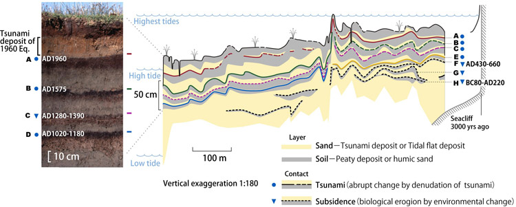
A total of 60 trenches were excavated in a 2 km square area in the survey site to observe the deposits of a depth of 1- 1.5 m (Fig. 2). The salt marsh usually consists of peaty deposits, but a sand layer transported by the 1960 large tsunami covered up to 15 cm thick in this area, an event which was witnessed by local residents. On the trench walls, it can be observed that the sand sheet of 1960 tsunami denudated partially underlying soil, and the sand sheet itself was apparently covered by overlying soil. Same relationship between sand sheet and soil has been identified in the lower repeated alternating beds.
In addition, evidence of coseismic subsidence can be detected from sedimentary structure of some boundaries between the soil and sand sheets which were biologically eroded by tidal animals such as lugworm. Therefore, it is suggests that similar magnitude of tsunamis and crustal movements accompanying earthquakes have recurred in the past. Evidence for a total of 8 major events have been found in these layers, which are classified as A-H in order from top to bottom (with A representing the 1960 earthquake).
From each of these soils, in situ plant fossils were collected and radiocarbon dated. The results showed that B was correlated to the 1575 earthquake, and the other events were estimated as follows: C: AD 1220-1400; D: AD 990-1190; F: AD 430-660; and H: BC 80-AD 220. These findings clearly indicate that great earthquakes occur in this region about every 300 years. This recurrence interval is in accord with geophysically calculated 250-350 years interval form the worth of convergent plate motion as a rate of 8.4 cm/year.
 |
|
Figure 2 The geological and geomorphological profile obtained from the trench survey in the salt marsh showed evidence that alternating layers of soil and sand sheets had deposited on top of one another. Geological evidence in these layers indicates that over the past 2000 years, there have been a total of 8 instances of tsunamis and ground subsidence, including the 1960 earthquake, and that these incidents occur about once every 300 years.
|
The trench survey did not uncover evidence of the 1737 and 1837 earthquakes, although they are described in the historical records. This indicates that these two events were of a lesser scale than the 1960 earthquake, and were not accompanied with tsunamis and crustal movement that were sufficient to leave a sedimentary records.
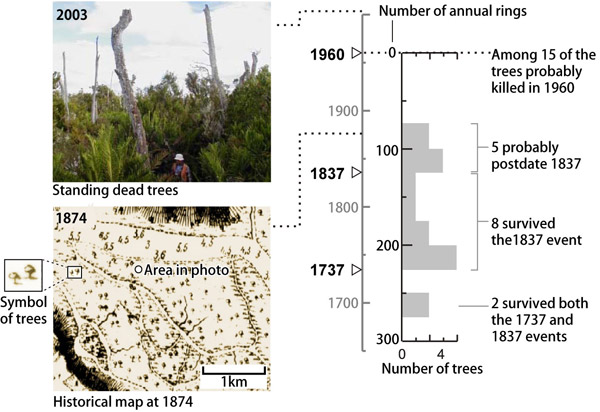
Even today, we can see many dead trees near the estuary of the Maullin River that were killed by submergence induced by ground subsidence during the 1960 earthquake (Fig. 3). Counting the annual rings of these trees, especially 15 standing dead trees with thick trunks, indicated that 8 of the trees had been growing before 1837, and 2 had been growing before 1737 and thus had survived one or both of the earlier earthquakes. Therefore, it can conclude that submergence of a same magnitude as the 1960 earthquake was not caused during the 1737 and 1837 earthquakes.
 |
|
Figure 3 Even today, we can see many standing dead trees near the estuary of the Maullin River that were killed by submergence induced by ground subsidence during the 1960 earthquake. Some of these trees survived the 1837 and even 1737 earthquakes, indicating that there was no ground subsidence during those two events.
|
Along the ocean trench off the south-central Chile, interplate earthquakes occur regularly at an interval of 100-150 years. However, great (Magnitude 9.0 class) earthquakes, such as the 1960 Chile earthquake, unusually occur at an interval of 300 years. This kind of characteristics is recently discovered in ocean trenches around the world. The 2004 Sumatra-Andaman earthquake is probably one recent example.